


On a quiet late-May morning in 2025, local visitors and residents were shocked to find that a section of the riverbank at Iford Playing Fields — a beloved public green space by the River Stour — had given way. Soil and large trees plunged into the river; paths that once ran alongside the water’s edge now ended abruptly at sheer drops. The collapse has triggered urgent concerns around public safety, environmental damage, and the long-term future of this community space.
This article explores what happened, why it happened, what the consequences are, and how the local authorities and community are responding.
Table of Contents
About Iford Playing Fields & Its Location

Where: Iford Playing Fields sits on the banks of River Stour, in the Iford area near Bournemouth/Christchurch in Dorset, UK. It neighbours a stretch of riverside paths, green open fields, and lies close to a train bridge opposite Bailey Bridge Marina.
What it is used for: The area is much loved by the community — used for walking, cycling, family recreation, sports, picnics, and as a pleasant natural riverside setting for leisure.
 Contextual vulnerability: This stretch of the River Stour has long been subject to natural river dynamics: tidal effects, variable water flow, periodic flooding, and historic catchment-area flood risk. Such conditions make riverbank zones inherently sensitive to erosion and collapse.
 Contextual vulnerability: This stretch of the River Stour has long been subject to natural river dynamics: tidal effects, variable water flow, periodic flooding, and historic catchment-area flood risk. Such conditions make riverbank zones inherently sensitive to erosion and collapse.
In short, while Iford Playing Fields has been a cherished public amenity, its riverside location always carried latent environmental risk.
What Happened — The Collapse Incident (May 2025)
When: The collapse is reported to have occurred around the end of May 2025. Residents recalled hearing a low rumble in the early hours, followed by the sound of trees toppling and falling into the river.
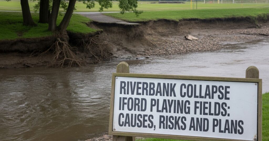
What collapsed: A “significant section” of the riverbank embankment — including soil layers and large mature trees — gave way. The bank’s edge collapsed toward the river, leaving behind a vertical drop (estimated around 2–3 metres in places), with uprooted trees partially submerged in water.
Visible effects: The adjacent riverside walking/cycling path cracked or slumped dangerously close to the new, unstable edge. Naturally, the collapse disrupted the continuity of the bank — what once was firm ground next to water became hazardous and unstable.
Immediate community reaction: Photographs and videos circulated on local social media and community groups almost immediately — showing soil missing, trees submerged, slumped edges, and calling for action. Residents expressed shock and concern over safety for walkers, cyclists, families, and pets.
Despite the severity, as of yet no definitive public geotechnical report has been released confirming the full extent (length, depth, and volumetric soil displacement) of the collapse — making the estimates largely based on visual documentation and local testimony.
Why It Happened — Contributing Factors
The collapse at Iford Playing Fields appears to have resulted from a combination of natural and human-linked factors. While there is not yet a public official geotechnical report, the causes — based on environmental science, local reporting, and hydrological understanding — can be grouped as follows:
1. Natural Riverbank Erosion (Toe Erosion)
Rivers constantly shape their banks. Over time, the flow of water — especially along bends or areas of stronger current — undercuts the base (toe) of the bank. This process gradually removes foundational support. In Iford’s case, the stretch near Bailey Bridge Marina is thought to have experienced persistent undercutting from the River Stour. When the toe erodes past a critical point, the soil above becomes unsupported, eventually slumping or collapsing.
2. Soil Saturation from Heavy Rainfall & Groundwater / Tidal Influence
In the weeks preceding the collapse, the area experienced prolonged heavy rainfall, saturating the ground. Saturated soils lose cohesion — the microscopic water between soil grains increases pore water pressure, reduces internal friction, and weakens the soil’s load-bearing capacity. This makes slopes especially vulnerable. Moreover, the River Stour at Iford is partly tidal/low-lying in sections — meaning water levels and backflows could impede drainage, keeping soils persistently wet.
3. Vegetation Loss and Root Structure Compromise
Vegetation — especially trees, shrubs, and deep-rooted plants — plays a critical role in stabilizing riverbanks. Roots bind soil, absorb excess moisture, and resist surface and subsurface erosion. On this stretch, many large trees fell into the river during collapse — evidence that root support had already been compromised, likely due to progressive undercutting and soil weakening. Once root systems fail, bank stability rapidly deteriorates.
4. Human Activity & Infrastructure Stress
The riverside paths in Iford are frequently used by walkers, cyclists, dog-walkers, and families. Regular foot traffic — and soil compaction from mowed lawns or informal landscaping — can degrade surface soil structure over time. Further, the presence of a nearby train bridge and possibly drainage or runoff systems may have altered natural water flow or added structural stress. While no official bridge damage was reported, experts consider that infrastructure proximity can exacerbate bank vulnerability.
5. Climate Change & More Extreme Weather Patterns
Local authorities and environmental commentators have flagged that changing weather patterns — wetter winters, unpredictable storms, heavier downpours — are placing traditional riverbanks under increasing stress. Such extreme events can combine with historical erosion to trigger sudden collapses. The Iford collapse may illustrate how long-term environmental stress and climate volatility converge to produce abrupt failures.
In combination, these factors — not any single cause — likely reached a tipping point in May 2025, resulting in the dramatic bank collapse witnessed by residents.
Impacts of the Collapse
The collapse at Iford Playing Fields has had significant and multifaceted consequences — ranging from public safety and community disruption to ecological damage and long-term environmental risk.
Public Safety & Recreation Loss
The riverside path and several adjoining areas near the playing fields were immediately deemed unsafe. As a result, authorities cordoned off large sections to prevent accidents.
Regular recreational activities — walking, jogging, cycling, family outings, informal sports — have been disrupted. The loss of easy access to the riverfront has disappointed many community members and local sports clubs.
There is an ongoing risk: even areas that appear stable may contain hidden soil slippage or underground cavities. Without proper assessment and remediation, ground movement could recur, especially after future rainfall or tidal surges.
Environmental & Ecological Damage
Large volumes of soil and debris entered the River Stour when the bank collapsed, increasing sediment load and turbidity — a potential threat to aquatic life, including fish spawning zones, aquatic plants, and invertebrates.
Uprooted and fallen trees, while loss of bank stability, may also disrupt riparian (riverbank) habitats — affecting birds, insects, small mammals, and plant species that relied on that terrain.
River flow patterns may have changed temporarily or permanently: fallen trees and debris can alter flow, create localized blockages, or shift how currents erode remaining banks — raising risk of further collapses or downstream erosion.
Potential Infrastructure Risk
The collapse occurred close to a train bridge near Iford. While no structural damage to the bridge has been officially confirmed, experts warn that continued bank erosion or repeated collapse could eventually threaten the ground supporting the bridge or related infrastructure.
Drainage systems, pathways, benches, and other park amenities near the bank have been damaged or rendered unsafe. Repair costs and long-term maintenance may require substantial resources.
Social & Community Impact
The sudden closure of popular riverside areas has deprived local residents of accessible green space — especially significant in urban/suburban settings where such spaces are limited.
There has been community frustration at what some feel was “neglect” — that the bank had weakened over years and that warnings or erosion-control measures may have been inadequate or delayed. This incident has sparked debates around how public lands near rivers should be maintained and monitored.
For families, sports clubs, and regular park-goers, the loss of safe access to the riverfront disrupts routines, recreation, and connection with nature.
In sum — the collapse at Iford Playing Fields is more than a one-time soil failure. It represents a ripple effect touching safety, environment, community life, and infrastructure.
Response & Remediation — What Has Been Done (and What Needs to Be Done)
Local authorities — particularly BCP Council (Bournemouth, Christchurch and Poole Council) — along with environmental specialists, have taken initial steps following the collapse. But experts stress that longer-term remediation and precautionary measures are critical to prevent repeat events.
Immediate Response
The affected zone was cordoned off swiftly. Warning signs were erected to prevent public access to unstable areas.
Initial site assessments by environmental engineers and soil specialists have reportedly begun, to evaluate soil stability, erosion extent, remaining risk zones, and potential danger to adjacent paths or infrastructure.
Temporary measures: in areas close to collapse, the council is considering temporary rerouting of walking/cycling paths, installing barriers, and forbidding river‐edge access until stabilization is assured.
Proposed Remediation & Long-Term Stabilization
Experts and environmental advocates suggest a mix of “soft” and “hard” engineering solutions, alongside ecological restoration:
Soft/ecological techniques: replanting native deep-rooted trees and shrubs, establishing buffer vegetation zones, restoring riparian habitats, and encouraging natural root-based soil binding. This helps in natural stabilization and reduces reliance on concrete or structural support.
Structural reinforcement: Where soil is severely undercut or banks are steep, installing properly engineered retaining structures — such as gabion walls, riprap, bio-engineered retaining slopes, or terracing — may be needed. Drainage improvements, slope grading and stabilization measures are likely on the council’s agenda.
Water-flow management: Since part of the problem arises from river flow and possibly tidal effects, monitoring water levels, limiting upstream surges, preventing abrupt flow changes (especially during heavy rainfall), and ensuring drainage systems don’t discharge directly into unstable banks are all part of long-term planning.
Community involvement & ongoing monitoring: Encouraging local community participation in monitoring, maintaining vegetation, reporting early signs of slumping or erosion, and preserving green buffer zones can make the difference between reactive and preventive management.
Challenges Ahead
The full scale of damage is not yet publicly documented: no comprehensive geotechnical survey report has been released. That means the actual risk to adjacent zones, infrastructure, and ecology may be underestimated.
Restoration and stabilization — if done poorly — can itself become disruptive: heavy engineering could disturb wildlife, alter natural flow, or reduce the green, natural character of the fields. The balance between safety/infrastructure and ecological preservation is delicate.
Future climate unpredictability: As weather becomes more erratic, with heavier rainfall and potential flooding, any repair must be resilient enough to withstand future stress.
Lessons from This Collapse — Broader Implications
The Iford Playing Fields collapse is a wake-up call on multiple fronts.
Natural riverbank zones are dynamic — what appears stable can gradually weaken; public spaces near water require periodic assessment, not just occasional inspection.
Importance of vegetation: Natural buffers — trees, shrubs, deep roots — play a key role in soil and bank stability; removing or neglecting them for maintenance or aesthetic reasons can have long-term risks.
Holistic planning for public spaces: When designing or maintaining parks, recreation fields, or public amenities near rivers, authorities must combine ecological, geotechnical, hydrological and climate-change considerations — not treat each discipline in isolation.
Community awareness & involvement: Public vigilance — reporting cracks, soil shifts, water seepage — can help catch early warnings before a dramatic collapse. Engaging citizens in conservation can also strengthen long-term resilience.
Need for proactive adaptation: With uncertain climate patterns, flood risk and extreme weather events are rising. Infrastructure and green spaces must be adaptive and prepared, rather than reactive.
What Comes Next — The Road to Recovery and Resilience
Comprehensive geotechnical and hydrological survey — to map soil stability, bank integrity, risk zones, and design long-term interventions.
Implementation of stabilization and reinforcement works, using a blend of nature-based solutions and engineered support where needed.
Riparian habitat restoration and re-vegetation — planting native species, re-establishing natural root-bound embankments, buffer zones, and habitat corridors.
Community engagement and monitoring programs — setting up a volunteer-driven watch or local group to report signs of erosion or risk, combined with regular official inspections.
Resilience planning for climate-related stress — flood modeling, drainage upgrades, early warning systems, and flexible maintenance plans.
Transparent communication with the public — about risks, timelines, restoration efforts, and long-term park management plans — to rebuild trust and ensure community support.
In doing so, Iford Playing Fields can hopefully emerge not only repaired — but stronger, safer, ecologically healthier, and more resilient.
FAQs
| Question | Answer |
|---|---|
| Where exactly did the riverbank collapse occur? | The collapse took place at Iford Playing Fields, on the banks of the River Stour, near the train bridge opposite Bailey Bridge Marina. |
| When did the collapse happen? | Local reports indicate the collapse occurred around late May 2025, overnight or in the early hours. |
| What caused the collapse? | It appears to be a combination of: long-term riverbank erosion (toe undercutting), saturated soil from heavy rainfall and tidal/groundwater effects, loss of stabilizing vegetation, possible human-related soil compaction, and climate-induced extreme weather. |
| Is the area accessible now? | As of the latest reports, the most affected zones have been cordoned off for public safety until inspections and stabilization measures are completed. |
| Has the local council responded? | Yes — the BCP Council has begun assessments, planned safety closures, and is reportedly working on long-term stabilization and restoration plans. |
| Is there a risk of further collapse? | Yes — experts warn that adjacent sections remain vulnerable, especially if remediation and vegetation restoration are delayed or insufficient. Ongoing monitoring is essential. |
| What will be done to restore the area? | Plans include a mix of structural reinforcement (retaining walls, slope regrading), ecological restoration (re-vegetation, buffer zones), improved drainage, and community-based monitoring to prevent future failures. |
| How will this affect local wildlife and water quality? | The collapse likely disturbed riparian habitats, increased sediment in water (reducing clarity), possibly disrupted fish spawning and aquatic plants, and altered river flow patterns — though some fallen trees may also become habitat once properly managed. |
| What can the community do to help? | Residents can avoid restricted zones, heed signage, report visible erosion or changes, support vegetation restoration efforts, and advocate for transparent, climate-resilient management of the playing fields. |
| Is this kind of collapse unique to Iford? | No — riverbank collapse is a known phenomenon, especially in zones where flowing water undercuts banks, soils are saturated, and vegetation is disrupted. Such events become more likely amidst changing climate patterns and human pressure on natural river corridors. |
Conclusion
The 2025 riverbank collapse at Iford Playing Fields is a stark reminder that natural landscapes — even those long regarded as stable community green spaces — are dynamic and vulnerable. What may seem like harmless riverside stroll paths may be perched on soil teetering on the edge of collapse, especially after prolonged rainfall, tidal fluctuations, and erosion.
The event has upended recreational use, threatened local ecology, raised infrastructure-safety concerns and exposed long-standing environmental vulnerabilities. Yet, it also presents an opportunity: to rebuild wisely, restore ecology, adapt to changing climate realities, and involve the community in protecting a cherished riverside space.
If authorities, experts, and citizens collaborate — combining ecological conservation, engineering, and mindful urban-nature planning — then Iford Playing Fields can not only recover — but become a model for resilient, sustainable and climate-aware riverside green spaces.